Weather Stations - Columbia Weather Systems header bar
Home
Weather Stations
Weather Monitoring Applications
Newsletters
CWS Weather
Weather Links
More Weather Info
About CWS
Contact Us
 
Price Quotes
1 888-508-7375

Email


Recap March 2005 Newsletter

March 2005

This newsletter is also available in Adobe Acrobat format


Western Fire Mitigates Wildfire Weather Hazards with Capricorn 2000EX™

Vehicle Mount Weather Station Fire Truck with Weather Station

Mitigating Wildfire Hazards

Western Fire Inc. of Casa Grande, Ariz., provides "advanced firefighting technology and terrorism defense" through their compressed air foam products, contract services, consulting and training. Their fleet of trucks is contracted with the State of Arizona and federal agencies for wildland firefighting around the nation.

An evaluation of hazards revealed that weather conditions (such as shifting winds) caused many accidents and deaths in wildland firefighting operations. To help mitigate those hazards, the company decided to invest in weather monitoring equipment.

After seven months researching the market, they purchased four weather stations to mount on their wildland interface trucks. Bob Krempasky, VP of product development, explained why they chose the Capricorn 2000EX Vehicle Mount: "Columbia came out on top due to exceptional workmanship, top-of-the-line parts and sensors. Everything about it spelled absolute quality product."

Invaluable Tool

"Understanding the weather out on the fire lines allows us to provide information to the incident meteorologists and the surrounding firefighters, so that we can get them out of harms' way when the fire behavior changes," Krempasky said.

Western Fire is also part of Pinal County's HazMat, WMD, and explosion response teams. "We found that the weather station became an invaluable tool in helping to mitigate those potential scenarios," Krempasky stated. "We work closely with the county to provide critical weather information needed to evacuate people, to keep first responders upwind, and to do plume design and estimate how far chemicals are being spread."

"We initially looked at the weather station for firefighter safety and it just grew into bigger and other opportunities and ways to use it," he added.

As an FAA approved portable weather station, their Capricorn 2000EX weather station is also used to support air operations.

Western Fire is working closely with Columbia Weather Systems to develop the meteorology curriculum for their Southwest Fire Academy.


return to top

Monitor weather conditions with new WeatherMaster™ software including Fuel Moisture

WeatherMaster weather station software offers emergency responders the latest technology to help mitigate the effects of weather conditions on HazMat, rescue, and incident response operations. New fuel moisture calculations offer critical wildland firefighting data.

The software can be used to monitor environmental conditions from a single weather station, including vehicle-mounted or portable units; or it can be used to connect an entire network of stations, for example at critical points around the county.

WeatherMaster incorporates real-time monitoring of measured and calculated parameters with a web interface. It provides on-the-fly graphing and reporting capabilities and hazardous weather alarm notification.WeatherMaster interfaces with CAMEO/ALOHA for HazMat plume modeling and evacuation corridor forecasting.

Fuel moisture data, used to determine forest fire danger ratings and help predict fire behavior, is now available along with the standard meteorological parameters. The readings are based on ambient air temperature, relative humidity, wind speed, rainfall, and solar radiation data from Capricorn weather stations. Data are calculated for 1, 10, 100, and 1000-hour fuel sticks.

The new calculations replace the traditionally high-maintenance, fuel moisture stick sensors by using the Nelson Fuel Moisture Algorithm to estimate the percentage of moisture contained in small forest fuels.

WeatherMaster Fuel Moisture


return to top

Understanding Fire Weather

by John Gerrish, Sales & Marketing Director, certified meteorologist

Fire  Ridge
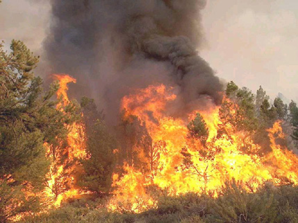
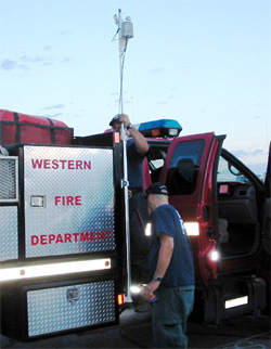
Photo courtesy of Western Fire, Inc.

Folklore tells how Indian ancestors used fire to rejuvenate the land, create new vegetation as a food source for game, and control underbrush. However, in modern times communities are springing up where suburbia meets the undeveloped countryside and wildfires are an ever-present danger in the Urban/Rural Interface.

Wet winter means more fire fuel

The western United States receives most of its precipitation during the winter months, with summers being relatively hot and dry. Vegetation receives ample moisture for spring growth, but by the time summer arrives, the vegetation has dried and becomes fuel for wildfires. Generally speaking, the wetter the winter, the more fuel there will be for the fire season.

The summer monsoons reach the Desert Southwest and Intermountain region when massive high-pressure systems stagnate over the Midwest. The general clockwise flow brings warm moist air from the Gulf of Mexico across the central Mexican plateau until it meets the Sierra Madre Mountains and the Intermountain Region of the American Southwest. This warm unstable air can extend as far north as the Canadian border and as far west as the Pacific Coast. Moist air is naturally more buoyant than dry air, thus relatively unstable.

When coupled with local mountain topography (called orographic lift) and diurnal heating, this monsoonal air mass triggers thunderstorms. Heat lightning results when thunderstorms develop but produce little or no rain. Virga (rain that falls but evaporates before it reaches the ground) leaves the land parched. And lightning sparks fires in these tinder-dry areas.

Wind is a major concern

Wind is caused by differential heating, which causes differential pressure within an air mass. For example, mountains are cooler than valleys because of the elevation. The cooler, denser air sinks and replaces warmer, less dense air on the valley floor, creating wind.

Wind is normally funneled through valley passes, which intensifies its effects. During wildland fires, wind fans the flames and can cause a fire to spread out of control.

Fire, itself, is one of the few natural phenomena that can create its own microclimate. Large fires heat massive amounts of air causing it to rise into the atmosphere; this is known as convection. Cooler surface air from outside the fire zone creates in-drafts to replace the rising air. This causes violent winds, which fan the fire.

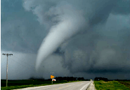
Coupled with low humidity and rough terrain, these extremes seem to take on a life of their own and create devastating firestorms. Firestorms can generate fire whirls, which are fire vortexes or small tornadoes, reaching as much as 500 feet in diameter and extending hundreds of feet in the air.

Katabatic winds

Another wind phenomenon that wreaks havoc with firefighters is the infamous Santa Ana winds. The Santa Anas are actually katabatic winds, normally created during the fall and winter months by colder, denser air pooling and piling up over the higher desert elevations of southern California. Katabatic winds in other parts of the world are known as Chinook or Foehn winds.

When pressure spills through mountain passes, it creates powerful winds funneled and warmed through atmospheric compression. The atmosphere dries as it descends, removing any available moisture from the environment. These conditions are further exacerbated by strong northerly winds in the upper atmosphere passing perpendicular across the local mountain ranges causing a natural "chimney effect" to occur. Add fire to the mix and it's a natural recipe for disaster.

Santa Ana conditions can last for several days to a week and can blow in excess of 80 mph over the entire region.

Predicting fire behavior

Fire meteorologists at the National Interagency Fire Center in Boise, Idaho have the daunting task of providing fire weather forecasts with sufficient detail to help predict fire behavior. In most wildland locations, real-time weather data is sketchy, so meteorologists don't have the necessary tools to base their predictions on. The National Weather Service and NOAA work closely with meteorologists to help predict atmospheric conditions, but this is a monumental task.

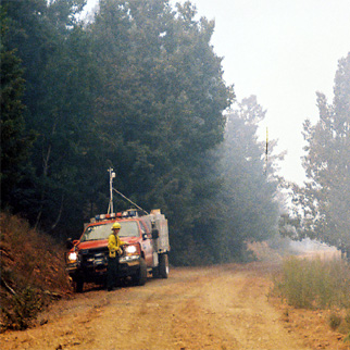
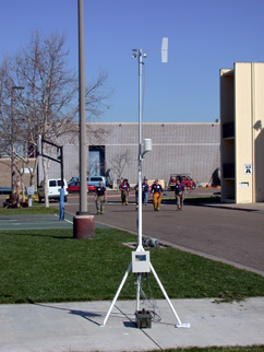
Private companies, such as Columbia Weather Systems, are now rigging wildland fire trucks with automated weather systems to put on the fire lines. Data is then sent back to the Incident Command meteorologists in the field. This information is essential in helping predict fire behavior in real-time and in strategic locations where the fire is actually being fought.

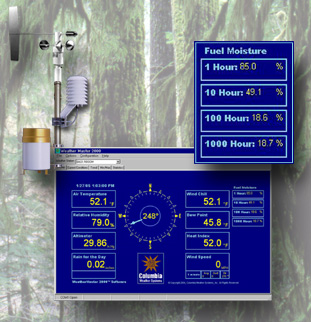
In addition, fire hazard monitoring at ranger stations can be enhanced with WeatherMaster weather software which incorporates calculated fuel moisture readings. The calculations are based on environmental parameters and replace the traditional and cumbersome fuel sticks.

In the realm of wildland firefighting, knowing the weather conditions helps define the rules of engagement. Each year millions of acres of timber and grasslands are burned and the property damage ranges in the billions. More importantly, lives are lost. Giant strides have been made to effectively manage our forests and minimize the fire fuels. Our best efforts will not eliminate wildland fires, but it will help protect the heritage we pass on to future generations.


Events

Pegasus Weather Station

Firehouse World Expo

In February, John Gerrish represented Columbia Weather Systems, Inc. at the Firehouse World Expo. In addition to manning the booth, John presented in the Hands-On Training sessions for Fire Control 3: Wildland and the Structural Fire classes at the San Diego Fire Academy where he demonstrated the Pegasus portable weather station.

Free Lunch at the Northwest Fire & Rescue Exposition

May 20-21, CWS will be close to home at the Portland Expo Center. Previously located in Eugene, this annual event draws members of the Fire, Emergency Medical, and Rescue services from around the region and includes a free lunch. For free tickets, contact John Gerrish at jgerrish@columbiaweather.com or 1 888 508-7375.

Oregon AMS Presentation

Tornado Chasing was the topic of John's lecture to the March meeting of the Oregon Chapter of the American Meteorological Society. His exciting presentation included photos and video from F5 Tornado Chasing Safaris, and was received with a standing ovation.

For more information, and to book your seat on the 2005 trip, call 1-800-845-0383 or visit f5tornadosafaris.com. Watch for our next newsletter which will feature highlights from the upcoming tornado chase.

Tornado Weather photo
June 11, 2004, Spencer, Iowa
Photo courtesy of AnythingWeather.com


return to top

©Copyright 2005 All rights reserved, Columbia Weather Systems, Inc.