Weather Watching
HazMat Weather Part I: Mitigating the Unthinkable
by John Gerrish, certified meteorologist
New scientific innovations occur all the time and new products are brought to market making our lives better and easier — computers, the Internet, cell phones, compact discs, lasers. Where would we be without satellite communications, plastics, synthetic and composite “man-made” materials that are stronger and lighter than steel?
These new products don’t come without a cost. Many of these materials are developed using petroleum-based materials, caustic chemicals, corrosive acids, and complex chemical compounds which are hazardous to people and the environment. The waste products from these processes and materials are also harmful; containing and disposing of them is problematic. Accidents happen. Even worse, what about deliberate acts of sabotage and terrorism?
Hazardous Materials (HazMat) primarily come in three forms: radiological/nuclear, biological, and chemical.
From 1995 to 2004, there have been over 150,000 HazMat related incidents and accidents on our nation’s highways, waterways, airways, and railways. Over 5,000 have been classified as “Serious Incidents.”
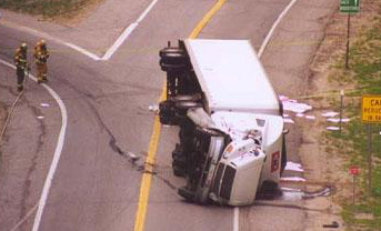 |
Many industrial sites store or transport HazMat chemicals in pressurized liquid or solid form. When these chemicals are exposed to air, they can instantly vaporize and be carried on the wind.
Businesses store hazardous materials. Pool and Spa outlets store enormous amounts of chlorine-based products. Many fertilizers are chemically based and can be extremely volatile when mixed with petroleum products, as evidenced in the Oklahoma City bombing. The methamphetamine epidemic in our country requires caustic chemicals that are extremely dangerous and toxic.
|
Because many chemicals or chemical compounds are highly flammable or even explosive, city ordinances now require businesses that store toxic chemicals to mark their buildings with symbols to notify emergency and fire personnel what types of chemicals are stored inside.
Terrorism
September 11, 2001 changed our world forever. We were served notice of an emerging and deadly threat. Not only do we have to prepare against accidents and incidents, now our emergency responders must become prepared and trained against deliberate acts of terror and weapons of mass destruction.
County, state, and federal officials have formed agencies to prepare for the unthinkable — from railroad accidents with hazardous materials, to highway incidents, to deliberate acts of terror.
Biohazards — bacteria and virus strains such as Anthrax, Typhoid, Small Pox, Bubonic Plague, and Cholera — can also be carried on the wind or through our water systems. Plagues wiped out over 25 million people, one-third of Europe’s population, between 1347 and 1352. In Asia, millions died of Cholera. Although an accident of this magnitude is unlikely, a deliberate act of terrorism is a frightening thought.
In the early 20th century, unethical warfare brought these biological agents to the battlefield to kill the enemy en masse. Today, these airborne virus and bacterial agents can contaminate an entire geographical region and spread rapidly, infecting a large population center in a very short time.
A nuclear accident is unthinkable, but the threat is extremely real. Chernobyl is a prime example where nuclear radiation spread downwind for hundreds of miles, contaminating everything in its path. A “dirty bomb” is a relatively small nuclear device designed to create a low-yield explosion and a high-contamination debris/dust cloud. Minute dust particles contaminated with radiation would be carried far downwind to pollute everything they touch. Ground Zero and the surrounding area could be uninhabitable for years.
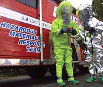 |
Our first line of defense is our local fire and police departments.
County, State, and Federal Emergency Management agencies, fire departments, and HazMat teams are trained to recognize a threat and take action. They respond to contain and neutralize the effects of potentially deadly toxins. Accident and Incident Commanders are highly trained in mitigation techniques. Through all of this, one constant holds true: airborne contaminants pose the greatest threat to the population.
|
Knowing precise weather conditions is vital to HazMat mitigation.
Wind, temperature, humidity, and other atmospheric conditions are paramount in determining downwind contamination areas, chemical dispersion rates, and evacuation areas. Knowing the character of the atmosphere is like knowing battlefield terrain.
Computerized Toxic Chemical dispersion programs have been developed to decipher the character of airborne chemicals and to predict their character. These modeling programs complement the decision-making tools an Incident Commander has at his disposal. However, with ever-changing weather conditions, the variables soon get beyond the scope of the software. By automatically ingesting weather data into computer programs such as CAMEO/ALOHA (Computer-Aided Management of Emergency Operations/Areal Locations of Hazardous Atmospheres) and MARPLOT (Mapping Application for Response, Planning, and Local Operational Tasks), Incident Commanders have the ability to make computer-aided decisions that affect both the mitigation process and any evacuations that may be necessary.
 |
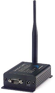
Weather monitoring equipment is a real force-multiplier. What used to take multiple personnel to compute and plot a toxic plume is now done automatically by computer generation. Mission-critical data is now instantly and continuously available. Data can be instantly transferred to keep all Command levels apprised of vital weather conditions and critical toxic chemical modeling.
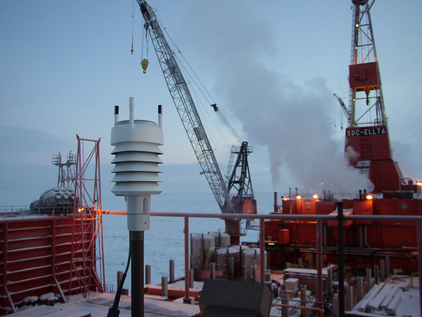
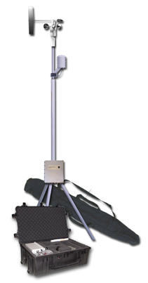
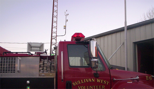
Automated weather stations mounted on emergency vehicles, Mobile Command Posts, and stand-alone portable weather systems are used to track weather conditions in tactical situations or in the middle of a “hot zone” from a safe distance.
|
HazMat Weather Factors
Wind Direction and Wind Speed. By knowing the wind’s character, experts can plot a toxic plume model to determine the scope of the contamination cloud.
Temperature readings are crucial because different chemicals vaporize at different temperatures. Some vaporize instantly when they come in contact with air, others vaporize at different ambient temperatures. Also, the warmer the atmosphere, the more vapor the air can hold, thus the more intense a plume cloud can become.
Relative Humidity readings are crucial because they indicate the percentage of moisture contained in the atmosphere, which can easily become contaminated by the toxic cloud vapor.
Dew Point Temperature indicates the temperature at which the atmosphere becomes totally saturated (100% humidity) and dew or fog may form. In a toxic environment, this means the toxic chemicals will be trapped close to the ground in a saturated atmosphere and persist until the weather conditions change.
Barometric Pressure is a strong indicator of the upward and downward air movement in the atmosphere through air density. When pressure rises, the air aloft is sinking downward. This creates higher pressure and often traps the air close to the surface. Consequently, if the pressure is falling, this means the air is rising upwards, thus creating the ability for the chemicals to rise up and disperse into the atmosphere.
Rainfall washes chemicals out of the atmosphere; however, this means that it contaminates the ground and/or ground water.
Water (or rainfall) also activates some chemicals - for example phosphine. This gas is used for pest control and as a fumigating agent. For farm use, it is often sold in the form of aluminum phosphide pellets, which yield phosphine gas on contact with atmospheric water.
Conclusion
Monitoring atmospheric conditions won’t stop accidents and incidents from happening, but it provides a powerful and valuable tool in mitigating their effects and protecting lives.
Look for Part II in the next issue of Recap.
return to top
|