| Call for a quote 1-88-508-7375 or Email |
| Home | Products | Applications | Newsletter | CWS Weather | Resources | Contact Us |
|
|
Autumn 2007 |
|||||||
This newsletter is also available in Adobe Acrobat format |
|||||||
|
|
|||||||
Air Evac Lifeteam Monitors Weather for Safety of Pilots, Passengers |
|||||||
|
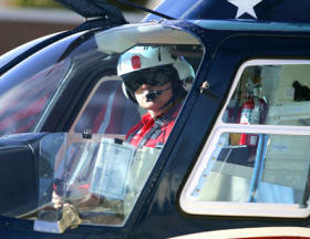
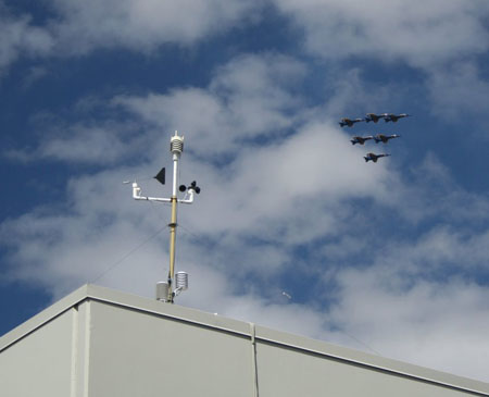
Air Evac pilots use real-time weather data and web cam images to plan their flights. ~courtesy photo |
Up-to-the-minute weather information plays a key role in the safety program of Air Evac Lifeteam, the largest independently owned and operated membership-supported air medical service in the United States. The company provides air ambulance services to rural markets in 11 Southern states. To help achieve Air Evac’s safety goals, they contracted with Anything Weather Communications, Inc., to establish a network of live weather monitoring sites with real-time weather data and live webcam imagery. The ‘AnythingWeather System’ is an all-in-one weather station/web camera solution that provides remote weather monitoring where computers are not available. Utilizing Capricorn 2000™ weather stations, the system requires only power and an Internet connection at the installation site. Currently, they have systems in Kentucky, Missouri, Texas, and Tennessee with the next systems scheduled for installation this fall in Indiana. |
||||||
|
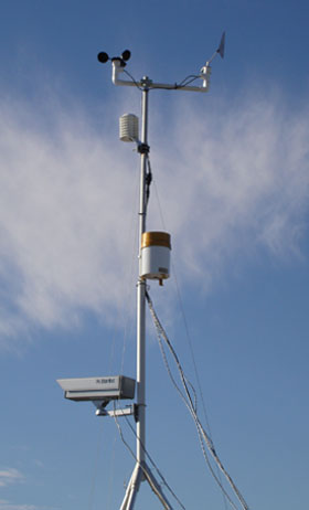
A Capricorn 2000 weather station with Anything Weather web cam atop a hospital in Missouri. ~photo by Anything Weather, Inc. |
Weather Data on the InternetLive, real-time weather data and images are displayed on a comprehensive weather website hosted by AnythingWeather.com. Most of the Air Evac AnythingWeather Systems are installed in remote locations tucked away in the middle of a valley or with near-by hills and mountains. Using the website, Air Evac pilots can determine whether it is safe to fly a helicopter into the area. Several systems are installed at hospitals, where the helicopters routinely fly their flights for life. By quickly checking the web site before a flight, the pilots can recognize if fog or other inclement weather presents hazardous flying conditions and if so, they decide on an alternate route to another hospital. In addition to the benefits of live webcam images, the real-time weather data can be used on-site to calculate variables such as estimated cloud ceilings, which helps the pilots make smart decisions that can save lives. AnythingWeather.com includes additional weather components for each site, including hourly and 5-day forecasts, active severe weather watches and warnings, and complete historical archive displays in a monthly and daily format. The best part about this network is that hospitals, the local community, and anyone with Internet access benefit. History of Safe Flights Translates to Peace of MindIn its 17 years of operation, with over 120,000 patient transports, Air Evac Lifeteam has experienced zero weather-related accidents. The AnythingWeather network gives Air Evac pilots peace of mind knowing that if the weather is bad and a flight for life is required, weather hazards can be avoided and lives saved, including those of the pilot and medical staff on board. |
||||||
|
|
|||||||
CWS News & Events |
|||||||
CWS Releases Redesigned WebsiteWe are very interested in your feedback. Email info@columbiaweather.com to let us know what you think.
|
|||||||
|
|
|||||||
New PLC-Compatible Weather StationIn response to customer requests, CWS has developed a weather monitoring system for industrial PLC interface. Applications include industrial operations such as manufacturing plants, water treatment facilities and power plants. The Orion 420 Weather Station measures wind speed, wind direction, temperature, relative humidity, barometric pressure and precipitation. With ultrasonic technology, the Orion 420 offers high accuracy and stability. This system includes a weatherproof enclosure housing a power supply, AC surge protector, and serial to 4-20 mA converters. Users will be able to view weather data on their PLC plant software such as Wonderware®. Features
|
|||||||
|
|
|||||||
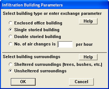
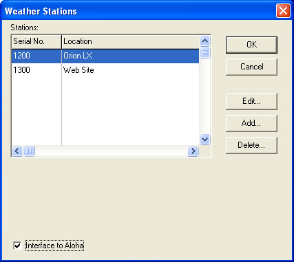
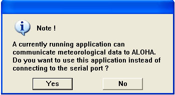
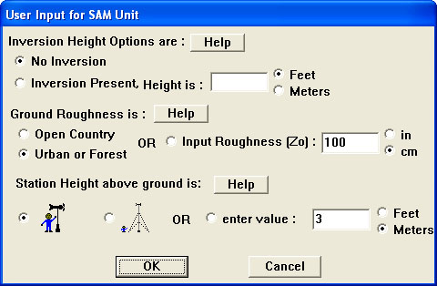
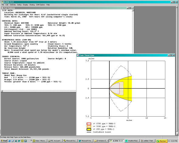
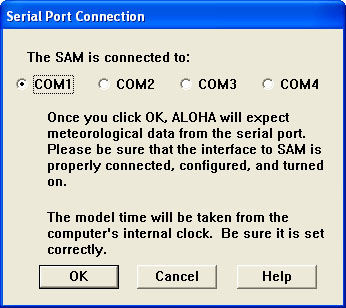
Most First Responders and Emergency Technicians are all too familiar with the threat of hazardous chemicals when responding to an accident or incident. From on-site chemical storage facilities to large tank farms to dangerous cargo, hazardous materials (HazMat) are ever-present in our world. To help mitigate toxic spills, accidents, or incidents, the United States Environmental Protection Agency (EPA) and the Federal Emergency Management Agency (FEMA) have produced the Computer Aided Management of Emergency Operations/Areal Locations of Hazardous Atmospheres (CAMEO/ALOHA) computer software program. CAMEO/ALOHA, in conjunction with MARPLOT, helps firefighters and emergency managers mitigate the effects of toxic chemicals leaked into the atmosphere. Columbia Weather Systems has developed a computerized interface with CAMEO/ALOHA, through WeatherMaster™ Software, that automatically inputs live weather readings for on-the-fly toxic plume modeling. The following steps are provided to interface the two software packages. I. Open Aloha software. A. Select SiteData from the top menu bar. A drop down sub-menu bar will appear.
B. Minimize Aloha software. II. Open WeatherMaster software with weather station powered and transmitting data. A. Click on Configuration tab on the top menu bar.
B. Minimize WeatherMaster. III. Maximize ALOHA software. A. Click on SetUp from the top menu bar. A drop down sub-menu bar will appear.
|
|||||||
|
|
 |
||||||
|
|||||||
B. Click on Display from the top menu bar. A drop down sub-menu bar will appear.
|
|||||||
|
|
|||||||
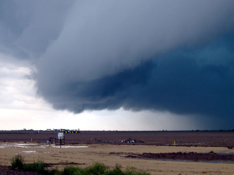
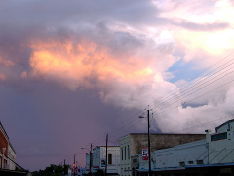
Diary of a Tornado Chaser: CWS Meteorologist Heads Tornado Chase TeamSpring 2007 produced another exciting tornado chasing season. May 6-12 was my week to head up the chase crew. Here are some of the excerpts from the chase log: Sunday, May 6The start of a new chase week. We changed crew – Jason Webb driving and John Gerrish meteorologist. Our destination was western Oklahoma, where several tornadoes were reported the evening before. One touched down and took the roof off the school in Sweetwater, Oklahoma. We drooled as we watched it on local TV. We were headed to the same vicinity in the morning… We engaged buildups about 30 miles west of OKC, but trudged on to the target area. Radar located an isolated (thunderstorm) cell and we positioned ourselves near the town of Gould, OK. As we watched the big cell, it was blackish-green and it displayed all the signatures; however, it just never developed any organization or rotation. Another cell developed to the south and moved north right in front of us. It was well organized and we saw rotation. Funnels dropped and dissipated, dropped and dissipated. At this point, we were about 1/2 mile away facing west as the storm passed from left to right. One funnel appeared from the side of the wall cloud and had particularly good tight horizontal rotation. We could see it roping toward the ground and were a bit uncomfortable with it being so close. If it touched down it would only be about 1/4 mile away from us. The funnel dissipated as we watched. Then it appeared again in about the same location, but was a bit more intense. We thought touchdown was imminent; very close, very clear, right in front of us. As we watched, it suddenly lost focus and rotation, and was gone. After watching some more, we chased as the storms moved off. Nothing more. Close, but no cigar.
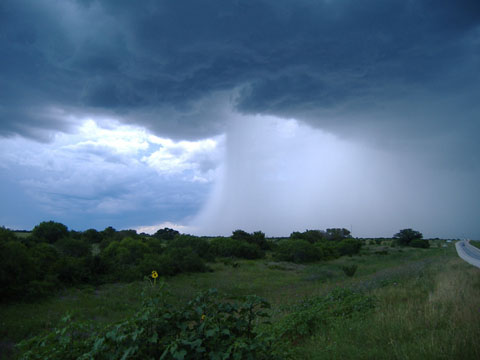
We ended up in the town of Menard and turned north, hoping to spot funnels or tornadoes. Weather radio reported a tornado 16 miles NE of Menard heading northeast toward the town of Brady, which was our next target city. As we approached Brady – in a complete downpour – the Baron radar failed, so we were operating blind – no radar and the visibility was about 100 feet – not a comfortable position with a tornado in the vicinity! We decided to break off the chase and get the heck out of Dodge – er, Brady – before something bad happened. We all were disappointed, but agreed it was the right decision. Tonight, we’re in Brownwood, TX.
|
|||||||
| ©Copyright 2007 All rights reserved, Columbia Weather Systems, Inc. |