Weather Watching: Storm Chasing Provides Dose of Excitement
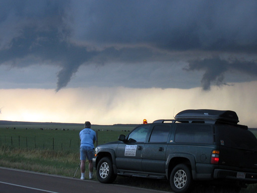
CWS's John Gerrish shoots a couple of funnel clouds. Photo courtesy of Anything Weather.
by John Gerrish, Sales Manager, certified meteorologist
One of the first tornado chasers was Pecos Bill. The legend tells that he lassoed and rode a Kansas twister all the way to Texas. My experiences haven't been quite that exciting, but modern-day tornado chasing is big business.
Why is this? Why do people risk danger to experience these potentially deadly storms? For some, it's the adrenaline rush. For others, it's encountering the awesome forces of nature up close, and sometimes very personal. For me, it's a little of both.
Meteorologists see weather through different eyes than most. Sure, we see clouds, rain, thunder, and lightning, but we also see the atmospheric dynamics - nature's physics in perpetual motion - and the awesome power of Mother Nature in mathematical terms. We also speak our own language - jargon such as mesoscale cyclones (or Meso for short), Super Cells, Helicity, Vorticity, CAPE (Convective Atmospheric Potential Energy), and Vertical Velocities are all part of our vernacular. We salivate when a Hook Echoes, Line Echo Wave Patterns (LEWPs), or Outflow Boundaries develop. We get excited when Squall Lines trigger massive thunderstorms that generate funnels and tornadoes. It's in the blood.
Approximately 96 percent of the world's tornadoes occur in the American Midwest. Springtime brings warm subtropical breezes from the Gulf of Mexico. These southerly winds sometimes become a strong gale, transporting Gulf warmth and moisture to the northern-most Plains. While winter has not totally relinquished its grip over the Midwest, hot dry air masses from the desert Southwest expand and extend into the Plains to set the stage for some of the most violent weather on the face of the planet.
I chase with F5 Tornado Chasing Safaris. Our guide Gregg Potter is the senior meteorologist and an experienced storm chaser. Our chase tours start in Oklahoma City. The number of chase vehicles depends on the number of clients for any particular week.
A regular passenger is Geoff Mackley, a well-renowned free-lance photographer/videographer who documents our chase season. Geoff's work has been shown on the Discovery, National Geographic, and Travel Channels. Geoff is a weather junkie, like the rest of us, only with an eye for the spectacular. (To see his work visit www.rambocam.com.)
Setting the Stage
Most mornings start with a conference call to meteorologists in the forecast office. Logging onto several weather websites, we discuss the day's potential and possibilities for severe weather. After arriving at a consensus "target-city" where the potential is the greatest, the meteorologists discuss the day's game plan with the clients, and we set out on the road.
Some days have little to no potential, and so become either tour days or travel days to position ourselves for predicted storms. Other days, the game is on and travel could be as short as 30 minutes to several hours. Travel time is used to conduct mini-Weather 101 classes, discuss atmospheric conditions, familiarize clients with weather jargon, and answer questions.
Our on-board laptop computer utilizes an XM-Satellite weather program called Baron'sT, which provides realtime weather radar, GPS tracking, wind profiles, satellite imagery, time-lapse looping, and "on-the-fly" severe thunderstorm/tornado warnings and advisories - all in the vehicle and at 70mph! Baron's radar dissects a storm both horizontally and vertically, to help us position ourselves close to the most severe weather and be in place to observe pure, raw nature at it's worst, er uh, best.
Positioning
This season, we caught up with a series of severe storms in the Texas panhandle. We'd driven south from Nebraska and engaged the thunderstorms near Quitaque, TX, a small village east of Plainview. As we positioned ourselves near Caprock Canyons State Park, we came across other tornado-chasers, including a large radar truck from the University of Oklahoma. We were watching storms in the distance develop funnels, but nothing became noteworthy. The storm was known as an "HP" storm (High Precipitation), which are not typically good storms to chase. HP storms usually have low ceilings, heavy rain-shields, and/or hail-shafts that obscure visibility and often hide tornadoes.
We repositioned ourselves about half a mile south of Quitaque to pick the storms up from a different perspective. This put us on the storm's right-rear quadrant and in prime position to observe any severe weather. A warm humid southerly wind was blowing at our back as the storm grew. The black sky smelled pungent with rain as the clouds swirled overhead. Occasionally the sun shone through to illuminate a brilliant foreground on the ominous sky. We could hear the tornado sirens wailing in the distance as we watched and waited. Nothing.
Outflow boundaries formed and swirled dust and dirt into the air. Rain started and stopped. Golf-ball-sized hail sprinkled around us, but nothing more. As the sun set, the sky drew dark quickly. Continuous lightning filled the air, but no tornadoes. The wind shifted from a warm breeze to a cold northwest wind, an indicator that the storm cell was collapsing and then regenerating.
As the sirens subsided, we headed towards our next town, staging ourselves for the next day's chase. In this remote section of Texas, paved roads are at a premium. Our only route was through the storm we had been chasing, so we ducked our heads and headed through the belly of the storm. Golf-ball-sized hail pounded the vehicle so hard it made our ears ring. It was quiet inside the Suburban as we drove through the hail and rain, except the bleating from the XM satellite radar, "You are approaching a twisting storm, please exercise caution."
At one point, five "twisting storms" on the radar surrounded us. Rain fell so hard we couldn't see the road and had to slow to a crawl. Large hail littered the highway. Nonstop lightning lit the sky and several bolts hit telephone poles and trees very near us. We finally made it to Childress and got to our hotel. It was late and we were exhausted, but we were still riding the adrenaline rush from what we just experienced.
Debris field on the ground!
The next morning, our target city was Paducah, TX - about 30 minutes south. It was noon and the storms were already building. The day promised to be explosive. We headed east of town and ran into the usual crowd of storm chasers and tour vehicles. Most had entrenched themselves and were waiting for the fireworks to begin. Our radar indicated that some of the cells were "right-movers" - a clear sign of potentially severe storms.
We repositioned south of town on a lonely rural county road. We spotted a Super Cell, with its signature rotating cloud base. Strong storms such as Super Cells rotate counterclockwise throughout the entire storm column. As the storm rotates, the dynamics spawning tornadoes are already in motion and are manifested in the rotating structure.
Funnels appeared, then retracted, then developed again. Debris field on the ground! One of the funnels had touched down. Tornadoes are often transparent until the debris field sucks dirt and debris up into the funnel cone, giving it the classic dark shape.
We were less than a mile away and the only chase team around. We called 911 and reported the twister, which immediately set off the National Weather Service's Tornado Warning alert system for the county. The funnel was only on the ground for a minute or two before it rescinded and disappeared. A TV crew from Dallas was out filming the storms and stopped to talk with us as we watched this storm collapse.
Too close for comfort
We repositioned ourselves on the storm's right-rear quadrant and picked up Super Cell developing and spawning "fingers" - or multiple funnel clouds. We stopped about a half-mile away and watched as a strong funnel developed about halfway to the ground. Cameras were rolling. Debris field on the ground, but it was much closer than the funnel appeared. The debris field quickly expanded and we had a tornado on the ground within several hundred yards of us!
We grabbed our gear and scampered toward the Suburban. The wind hit, wrenching the door and sucking everything loose right out of the vehicle. As we took off, the tornado passed behind us, right where we'd been. That was close, but what a rush!
Several miles down the road, we stopped to regroup and inventory our maps and papers when another funnel dropped about a quarter-mile in front of us. An ominous black sky as the backdrop, the bright-green countryside with red plowed dirt backlit by the sun, and a magnificent red tornado looming in front of us! What a spectacular site!
This is what we chase for - to stand in awe of Mother Nature where words can hardly describe what our eyes see. We watched in silence as the twister meandered away from us, then quietly vanished back into the clouds. We savored the vision.
We had been up close and very personal with Mother Nature, and we had been satisfied.
For more info: www.F5TornadoSafaris.com
More photos: www.rambocam.com
return to top
|